


Le Glais Rouge

franquen
User
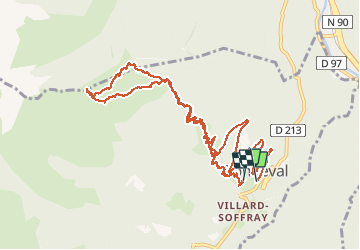

Length
12.5 km

Max alt
2122 m

Uphill gradient
1097 m
Km-Effort
27 km

Min alt
962 m

Downhill gradient
1165 m
Boucle
Yes
Creation date :
2020-03-01 07:22:05.281
Updated on :
2020-03-01 16:25:38.98
7h44
Difficulty : Easy

FREE GPS app for hiking
 SityTrail
IGN / Geographical institutes
SityTrail Plus
The world is yours!
About
Trail Touring skiing of 12.5 km to be discovered at Auvergne-Rhône-Alpes, Savoy, La Léchère. This trail is proposed by franquen.
Description
Très belle montée. Beau point de vue en haut
Positioning
Country:
France
Region :
Auvergne-Rhône-Alpes
Department/Province :
Savoy
Municipality :
La Léchère
Location:
Unknown
Start:(Dec)
Start:(UTM)
301117 ; 5044009 (32T) N.
Comments